

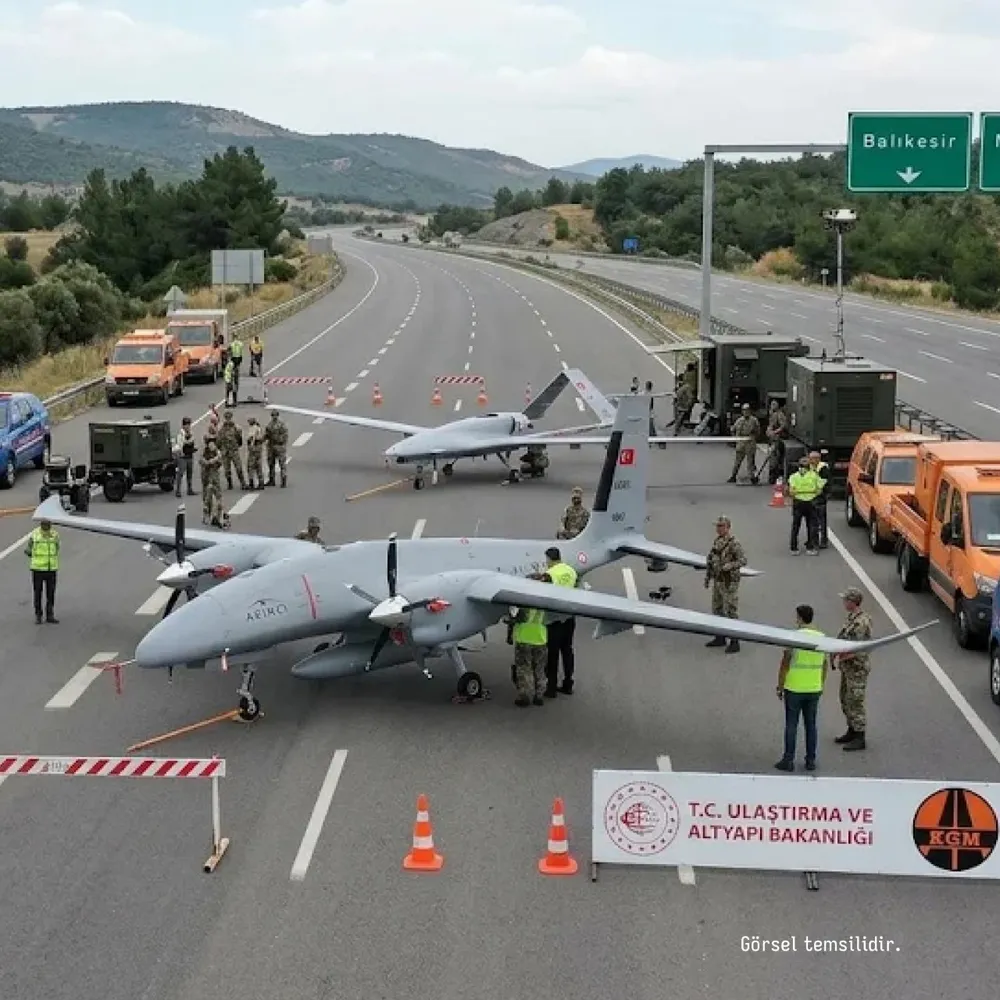
A strategic decision that combines Türkiye's defense and transportation infrastructure in a single pot is being implemented. The Ministry of Transport announced that highways will be used for unmanned aerial vehicles in possible emergencies and operational needs. With this new regulation, it is aimed to create UAV runways at determined strategic points. Within the scope of the planning, 52 different road sections throughout Türkiye were pre-marked to be used for this purpose.
The process is not just a plan on paper. Concrete steps have already begun to be taken. The highway between Manisa and Balıkesir was the first application area of this new system. The road was completely closed to traffic. What broke the silence were the giants in the sky. Our local and national prides, such as AKINCI and Bayraktar TB2, tested the functionality of the system by landing and taking off on the asphalt.
First Test for New Generation UAV Runways Successfully Completed
This trial, carried out on the Manisa-Balıkesir line, was carried out to see the limits of operational capability. It was personally measured in the field how suitable asphalt is for unmanned aerial vehicles that carry heavy loads and need to take off at high speed. While AKINCI's powerful engine sound echoed on the highway, Bayraktar TB2's sensitive landing maneuvers were followed instantly by the technical teams.
The main purpose of the tests was to see how quickly civilian infrastructure could be transformed into a military logistics center in the event of an air base being disabled or an operational crisis. The physical structure of the road, visibility and ground stability were examined meticulously. This application takes the understanding of "mobility" in Türkiye's defense doctrine to the next level.
Strategic Infrastructure and Defense Doctrine
Defense industry experts argue that such "dual-purpose" usage models are vital against the risk of fixed air bases being targeted. The use of wide and long highways instead of a fixed runway makes it difficult for enemy elements to identify targets. The fact that 52 different points have been determined provides flexibility spread all over Türkiye.
This shows that the logistics network will serve as a shield not only for civilian transportation but also for national security. Considering the range and mission duration of unmanned aerial vehicles, turning highways into temporary bases is an element that will directly affect operational speed. The power of asphalt now becomes part of the strategic superiority in the sky.
Future Plans and Implementation Process
This move of the Ministry shows that similar practices will be implemented on other critical routes in the coming period. The 52 determined points are categorized according to geographical distribution and strategic importance. Infrastructure works are planned to ensure that each point reaches the technical standards that a UAV will need.
Throughout the process, how road safety and traffic flow will be managed will be shaped simultaneously. Work is being done on the legal and technical protocols necessary to stop civilian traffic in emergency situations and turn that area into an air corridor. Türkiye appears determined to use every square meter of its territory to increase its defense capacity.
Source: BPT







COMMENTS (0)
Community CommentsNo comments yet. Be the first to share your thoughts on this story!